 Flooding
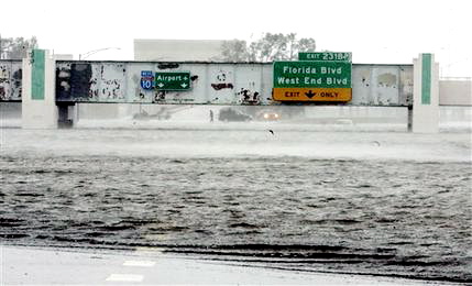
This is Interstate 10. If you have visited New Orleans, and you
traveled by air, you have probably been through here. It is the I-10
underpass near the Metairie cemetaries. You can see the "Airport" sign
over the lanes on the left. Florida Blvd is the exit you would take if
you were going to go over to Coop's house. There is a "ruler" on the
bridge support on the left to tell approaching cars how deep the water
is. I think it goes to 10 feet. It is entirely submerged. There is a
new pumping station that was built specifically to take care of this
area, but it overheated and shutdown, then was submerged in water.